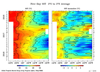

TAO/TRITON Five-Day SST
July 2016 to June 2018
Downtown Los Angeles (USC) has ended the 2017-18 rain year (July 1 to June 30) with only 4.79 inches of rain. That makes 2017-18 the third driest rain year since recordkeeping began in July 1877. The rainfall total was only 32% of normal and is less rain than was recorded during any rain year in our recent five year drought. The three driest rain years in Los Angeles have all occurred since 2001.
The June 2018 EL NIÑO/SOUTHERN OSCILLATION (ENSO) DIAGNOSTIC DISCUSSION says El Nino conditions are favored to develop during the Northern Hemisphere fall, and and this is the most likely ENSO state to be present this winter. According to the CPC/IRI consensus forecast there is a 50% chance of El Nino conditions developing this fall, with the probability increasing to about 65% this winter.
Keeping in mind last year's "failed" El Nino, the April-May value of the Multivariate ENSO Index (MEI) increased 0.9 SD to 0.47. This is just below the threshold of a weak El Niño ranking. Klaus Wolter's empirical analysis using historical analogues suggests that, compared to last month, the odds for the development of El Niño conditions later this year have dramatically increased.
If Los Angeles rain year precipitation is averaged for El Nino episodes (CPC ERSSTv5) since 1950, the average is about 120% of normal. However, El Nino conditions do not guarantee above average rainfall, particularly in the last 15 years or so. The driest rain year on record in Los Angeles (2006-07) was during an El Nino; and two rain years (2014-15 & 2015-16) of our recent five year drought were during an El Nino.
More information about Southern California weather and climate can be found using our WEATHER LINKS page.